 The Irish playwright George Bernard Shaw knew a thing or two about nationalism. He was probably thinking of the tragedy of his own country when he wrote “A healthy nation is as unconscious of its nationality as a healthy man is unconscious of his health. But if you break a nation’s nationality, it will think of nothing else but getting it set again”.
Alberto Alesina, William Easterly and Janina Matuszeski presumably also agree with that sentiment. The trio work for the US National Bureau of Economic Research and their thoughts on crooked nationhood are in an intriguing article they wrote called “Artificial States”. The paper examines the problems caused when political borders do not coincide with a division of nationalities desired by people who live there. The quote from Shaw is in the document’s introduction.
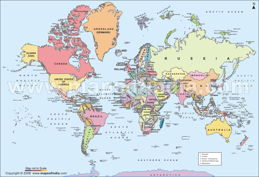
The paper looked at two measures of artificiality. The first looked at how borders split ethnic groups into adjacent countries. The second looked at the straightness of land borders assuming that the straighter the border, the more artificial it was likely to be. The paper showed that these two measures were commensurate with political and economic success. In other words, the more crooked or squiggly a border was, the more organic it was likely to be.
Artificial borders were created, in the main, by Europeans. Former colonial powers or war-winners bequeathed nice straight lines to the new owners with little or no regard for the make-up of the ethnic, religious or linguistic groups on the ground. Europeans had no time for these niceties. Instead territory was given to groups despite rival claims, coherent groups were often split, and sometimes large combinations were created of amorphous groups.
The borders that created the most friction tended to be drawn in straight lines based on longitude and latitude. Non-artificial boundaries are usually more squiggly and based on geographical features such as rivers and mountains or are long-term divisions carved out by different peoples. The researchers found that political instability, violence and war correlated with their measure of artificial states.
Examples of problematic borders abound across the globe. The 1919 Treaty of Versailles which formally ended World War One, was a political compromise between the winning powers. Ethnic boundaries and nationality were ignored in a shameless land grab and it set the seeds for a large number of future conflicts including World War Two. The map of today’s Middle East is also mostly the result of Versailles. Britain had earlier promised Emir Faisal an independent Arab emirates in the old Ottoman Empire. But this plan was gazumped by the secret Sykes-Picot agreement which divvied up the empire into British and French spheres of influence. Faisal was offered a new kingdom called Iraq cobbled together from three Ottoman provinces that were respectively Kurdish, Shiite and Sunni. In Lebanon, the French supported the Maronite Christians and bolstered their kingdom with Muslim areas around Beirut, Tripoli and Sidon.
The partition of India and Pakistan was another artificial border. Prior to the Raj, Hindus and Muslims alike ruled kingdoms of either religion. Muslims were in a minority in every region except in the extreme north east and north west. Ghandi and Nehru wanted a unified Indian state but Mohammed Ali Jinnah campaigned for a separate Muslim state which would somehow emerge out of the patchwork of Muslims scattered across the country. He ended up with a “moth-eaten” Pakistan with two pieces a thousand miles apart. The Bengali "East Wing" survived the disinterest of Islamabad and a genocidal repression before finally gaining independence as Bangladesh in 1971.
 Africa too has many artificial boundaries. Prior to decolonisation, states had to prove control of their territory to gain international recognition. Virtually all the new African states would have failed this test. But by the late 1950s, the rules had changed. So-called “letterbox sovereignty” ruled. The international community decided that who ever opened mail from the UN, the IMF or the World Bank would be deemed the government. These new states were run by little more than a few educated agitators supported by a remnant colonial army surviving on a foreign aid budget. The new rulers had no incentive to change the system that had put them into power. One of the earliest resolutions adopted by the Organisation of African Unity in the 1960s was to treat colonial boundaries as sacrosanct. It remains a fundamental plank of the African Union.
Like Africa, Latin America is bulging with artificial boundaries. Until the early 19th century the entire continent of South America (with the exception of Portuguese Brazil) was under the colonial power of Spain. The Spanish divided the continent into a series of captaincies, viceroyalties and presidencies. Liberators such as Simon Bolivar and Jose de San Martin drove out the Spanish but the newly independent states agreed among themselves to keep their national boundaries in line with colonial administrative divisions.
Old grievances about the east bank of the Rio de la Plata between Spain and Portugal were carried on by the successor nations Argentina and Brazil and the disputed territory eventually became the buffer nation of Uruguay. Indigenous groups were also split across countries with no regard for their fate. Although the US and Canada (as well as many of their states and provinces) had straight borders, this was due to the (apparent) emptiness of these areas at the time the maps were drawn.
 The researchers used a scale-invariant fractal measure to determine the straightness or squiggliness of any given border. Coastlines were disregarded from the analysis. The other key measure focussed on percentage of ethnic groups split across countries. The survey then looked at the top third of ethnically partitioned states and compared that to the top third of “straightest” border states and found 13 nations in both categories. These 13 so-called “most artificial” states were: Chad, Ecuador, Equatorial Guinea, Eritrea, Guatemala, Jordan, Mali, Morocco, Namibia, Niger, Pakistan, Sudan and Zimbabwe. They then measured economic and political success based on 2002 figures per capita income, health of political institutions based on criteria of accountability, stability, violence, rule of law and corruption, and quality of life (mortality, literacy, immunisation rates, clean water access). The only important variable not considered was war, which the researchers surprisingly believed was not a major factor. They acknowledge however it would be useful to include in future analysis.
 The conclusion was there was a strong correlation between artificial borders and political and economic success. The researchers believe they have offered a new means of making a determination on “failed states”. The legacy of the artificial boundaries bequeathed by colonisers are a significant hindrance to the political and economic development of independent states that inherited the colonies. The trouble is: try telling that to the leaders of those states.
No comments:
Post a Comment